Cruise Blog

Posted: September 15, 2015

All good stories must come to an end. So on Saturday morning, 6.30am, we picked up the pilot in the Solent, and slowly sailed along Southampton Water until we docked outside the National Oceanography Centre. By 08:30 the ship was tied up alongside, and the expedition was officially over.


Demobilisation started immediately, and in no time boxes, sampling equipment, containers and deep-sea vehicles were lifted onto the quayside. Suddenly our home for 5 weeks changed beyond recognition, and we realised the expedition was now really finished. Time to go home!

We all said our goodbyes, already making arrangements to see each other again in the near future. Looking forward to exchanging science results, catching up on new projects, and bringing back happy memories from our 5 weeks at sea.

The end of the expedition does not mean the end of this blog or Twitter feed, though. As we develop the research and the first results start coming in, we plan to keep you updated with what we’ve learnt about Whittard Canyon, about mapping complex deep-sea environments and about submarine canyons in general. So keep watching this space, we’ll be back soon!

The Itchen Bridge, seen from Southampton Water
Posted: September 11, 2015

This blog post was written by Jenny Gales, a postdoctoral researcher at NOC.

An important event towards the end of the cruise was testing a new ROV-based vibrocorer, a coring system that works by vibrating aluminium core barrels into the seafloor. The benefits of a vibrocoring system over traditional coring methods, such as piston and gravity coring, is the ability to core into sandy substrate: pure sand is notoriously difficult to core as the sand grains interlock under the weight of the core barrel. By vibrating the barrel this problem can be avoided. As the vibrocorer is mounted on the ROV, it also allows coring sites to be precisely targeted on the two ROV cameras and on the forward facing sonar. We tested this new system in shallow water (~200m water depth) and successfully recovered five sandy cores, making the shallow water trials a success. In the long run, we aim to use the system at full ocean depth, i.e. up to 6000m deep, where nobody has vibrocored before!


On one of the dives, we targeted a small area of sandwaves at the head of the canyon. During the dive we could locate ourselves using the forward facing sonar and vibrocore in precisely the correct location. This was a huge advantage over traditional coring methods, where it is often difficult to target specific areas of the seafloor due to currents causing drift on the coring rig as it is lowered to the seafloor. A second dive took us right into the middle of a sandy chute at the edge of the canyon. We could see steep walls surrounding the ROV on the forward facing sonar so knew that we were in the middle of the chute- exactly where we wanted to be. We look forward to using this system again in the future!


Virbrocorer mounted on the ROV Sandwaves seen in the forward facing sonar
Posted: September 09, 2015

This blog post was written by Inge van den Beld, a PhD student at Ifremer

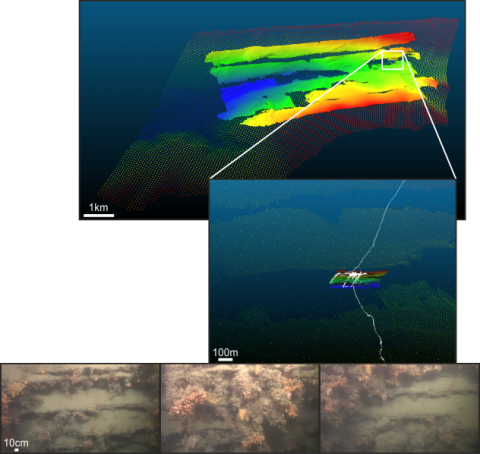
Last Friday night (4 Aug), ROV Isis was sent to the seabed one more time to take images of the seafloor of Whittard Canyon. The steep topography seen on the multibeam bathymetry maps, and video footage taken at nearby locations, suggested we would again encounter deep-sea corals during this dive. Deep-sea or cold-water corals are different from tropical corals as they live much deeper (below 200 metres water depth), can cope with colder temperatures (usually between 2-10°C) and do not need sunlight for their energy, because they lack symbiotic algae.

Earlier on the cruise, we investigated a wall on the opposite flank of this branch of the canyon using Isis. This wall was dominated by large colonies of colonial stony corals (mainly Lophelia), together with Ascesta bivalves, some gorgonian (seawhip or fan) species and a brown sponge. Therefore a similar community was expected on the (near-) vertical feature investigated on Friday night. However, although we saw many corals, the species assemblage was not really what we expected.

Large colonies of gorgonians, seen on the other flank, were dominating this flank of the canyon, while colonies of stony corals (perhaps not even the same species) were less abundant and smaller in size. The brown sponge was replaced by a white, cup-like sponge, and the Ascesta bivalves disappeared (except for one small patch). At the base of the vertical feature, large colonies of another stony coral, Enallopsammia sp., were encountered, and at the top, we saw large stylasterid hydrocorals.

The observed differences in community between flanks of the same canyon branch may be a result of the steep canyon walls being oriented at different angles to the current (which brings food and (coral) larvae), and possibly also due to differences in substrate. Initial analysis of Isis video suggest the rock type on this latest dive was igneous or metamorphic in origin, and very different to the sedimentary rock seen in the previous dive on the opposite side of the canyon.

During my PhD, I am studying the distribution of cold-water coral habitats and their faunal composition within the submarine canyons of the French part of the Bay of Biscay, including all canyons south of Whittard Canyon until Capbreton. During this JC125 cruise, we have seen many habitats formed by cold-water corals, ranging from gardens of gorgonians, fields of seapens comprising different species, and reefs formed by the colonial stony corals Lophelia pertusa and Madrepora oculata. Whittard Canyon is therefore very rich in terms of species, whether they are habitat-forming or not.

This is the first time that I have ‘visited’ Whittard Canyon, even though it is only a few nautical miles away from the northern part of ‘my’ study area. It is nice to see that the habitats I encountered in the French canyons are both similar and different from those in Whittard Canyon. Stony coral reefs on non-vertical terrain, some of the seapen aggregations, and a vertical wall dominated by Solenosmilia are habitats that are similar. However, some habitats in Whittard Canyon were new for me, for example the above described gorgonian and sponge community. On the other hand, fields of Funiculina seapens is an example of a habitat seen in French canyons but not in Whittard Canyon during this cruise. Some of the fish species swimming around in Whittard Canyon were also not known to me or only on paper, for example a fish probably belonging to the Halosauridae family.

Differences in benthic communities and dominant species between canyons may be caused by e.g. food supply, current directions, (investigated) depth range and/or substrate type. However, we haven’t investigated each centimetre of the 100 or more canyons that are present in the Bay of Biscay. So there is much more to explore and discover!

A fish that probably belongs to the Halosauridae family
Posted: September 08, 2015

This blog post was written by Tahmeena Aslam, a PhD student in physical oceanography at the University of East Anglia

Sometimes we have so many biological samples to process that even those of us (like myself) who work in a non-biological field are roped in to help. I study physical oceanography and until now I’ve never appreciated how “clean” data collection has been for me! Here are some of my thoughts from my few days as a biologist helping Laura to process the Acesta clams that she has written about previously:

It’s a bit disconcerting when your colleagues, who seemed fairly normal, suddenly whip out their dissection kits and gain a morbid fascination with slicing up flesh and muscle. And you’re trapped on a ship with them in the middle of the ocean with no chance of escape.

Processing samples involves getting very cold. Dissecting occurs in a cold room (4ºC), so as to preserve specimens. Cue wooly hats, multiple layers of clothing and jumping up and down to keep warm … in the middle of August.
Processing takes time.

Record keeping is key and we don’t want to waste any material that we’ve gone all the way to the bottom of the ocean to collect. Samples will be sent to multiple scientists to ensure that each life lost on the sea floor is not in vain.

No anthropomorphising of specimens allowed. Do you really want to name that shrimp “Dave” and then “preserve” him? No.

It’s weirdly satisfying! Doing something practical, when usually a lot of my work on a cruise is done sat behind a computer while my robot or instrument collects data, is really refreshing.

It makes you really think about the connections between the biology we see and the differing oceanographic and geological settings that they are found in. Why is this clam found here and not in that other part of the canyon? What influence does the water column or the geology have on their distribution? On an interdisciplinary cruise like this, it’s great to work with scientists from different disciplines and to start to figure out the reasons why amazing habitats, such as the ones found here in Whittard Canyon, occur where they do.

A selection of biology sampled on the seafloor by ROV Isis Acesta clam samples Laura, my patient biology teacher
Posted: September 07, 2015

This blog post was written by Katleen Robert, a postdoctoral researcher at NOC

One of the main aims of the CODEMAP cruise is to use innovative methods to map the seabed.  For many of the deeper areas, we still only have coarse maps for which many of the finer details, such as vertical walls, small gullies or coral mounds, are absent. However, these are important features, that play a big role in the local biodiversity in the canyon. To do the mapping, multi beam echosounders are usually used.   These sonars create a swath of sound across the path of the ship and measure the time for the sound to leave the ship, bounce off the seabed and return.  This gives estimates of the depths below the ship.  But to get more details, we need to get closer to the seabed.  This is where autonomous underwater vehicles (AUVs) like Autosub6000 or remotely operated vehicles (ROVs) like ISIS are useful; they can fly much closer to the seafloor (less than 100m).  Of course there tends to be a trade-off, as we get more and more resolution, we tend to be unable to cover very large areas.  This is why we still very much rely on ship-board multibeam to find target areas to further investigate using the AUV, and then use the maps resulting from the AUV surveys to decide on ROV video transects.

For one location in the eastern branch of the canyon, where a vertical wall covered in cold-water corals had been discovered during a previous cruise in 2009, here is an example of the different levels of detail that can be achieved using all the vehicles.

The first layer is part of a larger ship-board survey of the entire canyon branch (resolution ~50m), the second layer is from a ~25km2 AUV survey (resolution ~5m) (upper panel), and the third layer shows the previously mapped vertical wall (middle panel), a survey carried out using a multibeam mounted on the front of the ROV (~0.5m resolution).  The white track shows an ROV dive carried out during the CODEMAP cruise imaging overhanging cliffs covered in both hard and soft corals, clams and anemones (lower panel).

But in the end, why do we do this?  The information we get from the bathymetry allows us to derive other environmental characteristics such as slope (steepness and direction) or rugosity of the terrain.  As animals tend to select habitats with specific characteristics we can try to link these to where specific species occur, based on the collected videos and pictures.  Since we still lack information about the distribution of many species in our oceans, these links between species and their physical habitat can provide us with some information for areas we have not yet explored.

Posted: September 02, 2015

This blog post was written by Russel Wynn, a Senior Research Scientist at NOC

In addition to studying the deep-sea fauna of Whittard Canyon with our robotic vehicles, we have been recording marine life at the sea surface with more traditional equipment – binoculars! One of the scientific team, Russell Wynn, has been undertaking daily marine mammal and seabird observations, to better understand the range of species using the Whittard Canyon area and their habitat preferences.

The most spectacular sighting so far has been a Blue Whale, the largest animal on the planet, and probably first ever to be photographed in English waters! The huge mammal, twice as long as a double-decker bus, was seen on 24 Aug over a deep part of the canyon within the English portion of the UK EEZ. I had been watching up to seven Fin Whales around the ship when the Blue Whale suddenly surfaced about a kilometre away. It lingered just long enough to allow conclusive photos to be secured (and several people to see it from the bridge), before it disappeared in a band of rain and fog.

This sighting follows the first photographic record of Blue Whale off SW Ireland in Sept 2008. The species was hunted to near-extinction in the NE Atlantic region in the early 20th century, but these recent sightings, and others from observers on ferries crossing the Bay of Biscay further south, may indicate that the population is slowly starting to recover and move into new areas.

In these two photos the Blue Whale is surfacing and moving left; the dissipating blow is visible to the right in the upper image, with the mouth and splashguard (which protects the blowhole) on the left. In the lower photo the Blue Whale is preparing to dive; the mottled bluish-grey back and tiny dorsal fin are clearly visible.

In addition to the Blue Whale, over 20 Fin Whales (the second largest animal on Earth) have also been seen using the deep waters of the canyon, in aggregations of up to six animals. Other marine mammals recorded so far include Pilot Whales, hundreds of Common Dolphins and two groups of offshore Bottlenose Dolphins.

On the same day that the Blue Whale was seen, the survey team also recorded a Broad-billed Swordfish several hundred metres below the surface using ROV Isis. Swordfish are very rarely encountered in UK waters, and the footage obtained may also be the first of this species in the wild in English waters. Equally spectacular, up to 12 Blue Sharks have regularly been seen around the ship, and have also been captured on ROV video.

Seabirds have included rare Wilson’s Storm Petrels and lots of true oceanic wanderers such as the Great Shearwater, Grey Phalarope and Long-tailed Skua.

Redstart (upper image) and Reed Warbler (lower image); these birds were seen resting on the ship before continuing their migration to Africa.

Finally, we have also seen a few land bird migrants taking refuge on the ship, including species such as Wheatear, Redstart and Reed Warbler that migrate south to winter in sub-Saharan Africa.

With just under two weeks to go until the end of the cruise there will certainly be more interesting marine life sightings to come, so keep an eye on our Twitter feed for further news!


This image of a Broad-billed Swordfish was taken from video obtained using ROV Isis. The robotic arm of the vehicle is visible in the right of the image. This image shows two Blue Sharks, photographed by ROV Isis during its journey to and from the seabed. One of the most remarkable cetacean sightings was of a lone juvenile Pilot Whale, seen continually surfacing alongside the ship for most of the day on 18 June. This apparently orphaned animal was evidently in some distress, which became even more apparent when it reappeared alongside the vessel two days later some 50km to the southwest!
Posted: August 30, 2015

This blog post was written by Ella Richards, an AUV mechanical engineer at the MARS facility

One of the main tasks for Autosub6000 on the Codemap Cruise in 2015 is to collect high resolution echo sounder (multibeam) data depicting some of the vertical walls in the Whittard Canyon. In the AUV’s standard configuration, the multibeam sonar heads are pointing directly downwards and give very good topography of the horizontal parts of the seabed. Part of the Codemap science program is focussed on the geology and the animals that live on the steep, vertical or overhung canyon walls, which the multibeam system has trouble covering in detail. To gain the required detail the head that ‘hears’ the sonar pings from the transmitter, the RX head, has been tilted towards the canyon walls to be able to collect more detailed data from the canyon walls. Work on adapting the vehicle and the control software started over 13 months ago with concept and design meetings between members of the Autosub Engineering team and some of the Codemap Scientists. After the design specification was written, work was able to start on the mechanical changes needed to the vehicle and writing the code that would allow the vehicle to track the canyon at a constant distance from the wall.

Autosub6000 is capable of keeping a constant vertical distance from the seabed by using sonar pings from its ADCP (Acoustic Doppler Current Profiler). The pings tell it how far away it is from the seabed, and if it is too close the control centre of the AUV will tell its stern planes to move and the vehicle will increase the distance between the vehicle and the seabed. There is also a navigation system called the PHINS on the AUV that measures the pitch (whether the nose of the AUV is up or down), roll (whether the sub has tilted to port or starboard), and yaw (the heading of the AUV). Using the ADCP and the PHINS together, the AUV is able to follow a set of waypoints that plot a course across the seabed. Once the ADCP ‘locks on’ to the bottom it can pretty accurately tell the AUV in which direction it is going and how fast it is going, and hence where it is relative to the first point it made contact with the bottom.
In order to accurately track the canyon walls, the AUV needs to know the distance between itself and the vertical wall it is following, and needs to be able to adjust its heading by changing its rudder to avoid getting too close to the walls. James Perrett has written a piece of software that takes the multibeam data that the AUV is collecting, processes it with an algorithm that calculates the minimum horiztonal distance between the AUV and the canyon wall, and then converts this into a heading offset. Once this heading offset has been sent to the control centre of the AUV, the AUV will steer itself away from the canyon until it is at a safe distance. It will then carry on trying to follow the same track as before. In addition to the horizontal control algorithm, we have also had to ensure that we have safe ways of handling faults that the vehicle might have whilst canyon tracking. If the AUV’s rudder becomes stuck, or the multibeam system cuts out and fails to give us data to calculate the distance from the wall to name a few examples, the AUV will recognise that there is a problem, drop a large weight and head for the surface. The AUV can then be recovered and the fault fixed, before we have the added problem of it colliding with the canyon wall.

Tilting the RX head introduced some very interesting mechanical design challenges for me to solve. If the vehicle is too heavy, then it will sink when placed into the water and will be unable to surface; this is called the ballasting of the AUV. In order for the AUV to float level in the water, the weight has to be distributed evenly in pitch and roll, otherwise the AUV could end up pointing tail upwards, and be rolled over to starboard, and wouldn’t fly level; this is called the trim of the vehicle. Tilting the RX head could have had a large effect on the ballasting and the trim of the vehicle, as the RX head is very large and very heavy, unless the original positioning of the RX head was very carefully chosen to minimise adverse effects. More floatation had to be added to the vehicle to ensure that it wouldn’t sink, and it had to be added in the correct place to ensure correct trim. The mounting of the head had to be completely reversible, as the multibeam would be used in both its downwards and tilted configuration on the Codemap cruise. This meant that certain features of the design had to be thought about very carefully. The RX head is mounted underneath the vehicle, and is set into the centre section. It is mounted on a welded Aluminium wedge which is set at 20˚, with the transducer head pointing to Starboard, (See picture).

In the initial stages of the cruise Autosub6000 was being used to collect multibeam maps of the canyon with the RX head in its downwards configuration. We hope to improve the detail of these maps by doing passes over the same area with the RX head in the tilted position. At this current time, we are in the process of completing one of our first ever missions using this vehicle set up and the horizontal collision algorithm. The results will be posted in due course!


Autosub6000 on the Codemap Cruise in 2015 Engineering drawings of autosub
Posted: August 28, 2015

Paul Shawyer is studying Geology at the University of Southampton

Over the past few days the weather has been changeable in the Whittard Canyon resulting in fewer ROV dives as it has been too rough to launch. We have however been able to get sediment samples with a piston corer. My masters project is based on down-canyon changes in the character and timing of submarine flow events in Whittard Canyon. We are aiming to collect a series of piston cores which represent a transect across the lowest part of the canyon, the thalweg, where the main canyon arms converge in the deeper depths of the canyon, at around 4000 meters. Using new cores collected on this cruise along with cores collected on a past cruise to the Whittard canyon, JC36, we will be able to see the nature of sediment flows across the canyon.

The piston coring rig itself is a long steel barrel which can be 6/12/18 meters long with a plastic pipe of the same length inside, which is lowered down to the seafloor by a winch and then allowed to free-fall the last part and penetrate the sediment with the help of the heavy head weigh attached to the barrel. The piston part is attached to the barrel head and causes suction effect to the sediment upon pulling out of the seabed stopping the sediment core falling out of the tube. Once the rig is winched back to the ship and on deck the plastic pipe is removed from the barrel and cut into sections and split to allow us to see a record of the sedimentary history of the canyon inside. This is a very hands on and muddy task for the scientists on duty!

So far we have obtained 5 cores, two of which were very successful, with core lengths of 9 meters and 7 meters. These two cores came from terraces either side of the thalweg and show a decreasing trend from bottom to top of the size and frequency of sediment flow deposits suggesting the sediment input to the canyon decreased with sea level rise after the last glaciation event.

It has been a fantastic opportunity for me to be a part of this cruise and to experience the process of collecting the sediment cores. Being able to see the ROV dive footage and AUV data taken in the canyon has allowed me to understand the geomorphological processes active in the canyon at present and witness the rich biodiversity the Whittard Canyon is home too.


Sediment core laid out in the lab for inspection. Night-time recovery of the 12m long piston coring rig.
Posted: August 25, 2015

Gareth Carter is a marine geoscientist working at the British Geological Survey

Before leaving Edinburgh, I was gently warned by several colleagues that life on a research cruise would be very different from my normal 9-5 job with the British Geological Survey (BGS). Having spent two weeks on board the RRS James Cook, I can now confirm that this is indeed the case! The following is a brief summary of life on a research cruise for a first timer, and some of the lessons I have learned to-date:
4am… I can safely say that I have never consistently started work at 4am before in my life. That is one of the changes that really hit home very quickly when starting my first cruise!  This is a 24 hour research vessel and I work the 4 am to 4 pm shift. For the first few days I wandered around the science lab, like some form of zombie geologist with glazed-over eyes, unsure of where I was. Fortunately, a kind co-researcher took pity and introduced me to the good, strong coffee… the kind of brew that puts hairs on chests. Lesson No.1; a good mug of coffee is worth its weight in gold when on a research cruise!

Lesson No.2; meal times. I am a self-confessed foodie under normal circumstances but this has now increased to unhealthy levels of food fixation since boarding the RSS James Cook. As shifts are fairly long (12 hrs), meal times provide a time to relax a bit and chat with members of the other shift with whom you would usually have little contact other than at shift changeover times. An added bonus is that the food on board is delicious… “Steak Sunday” is a firm favourite with the crew and something I would be keen to continue with when I return home!

However, as you can imagine there is a slight drawback to having large portions of really tasty grub available to you three meals a day, but thankfully there is a small gym on the ship to help combat these unwanted side effects! Which brings me to lesson No. 3 I have learned so far… exercising on a rolling ship is easier said than done! Running on the treadmill can only be compared to running for a bus after an evening at the local pub; concentrating hard on putting one foot in front of the other without falling over! And hitting a punch bag that appears to have taken on a life of its own, swaying from side to side as the ship rolls, is a new experience and adds another dimension to working out!
Finally, I have learned the importance of having an upbeat, fun team around you. Sitting gazing at a computer monitor at 4am, clutching your rocket-fuel coffee and missing some of your home comforts, it’s easy to feel a little down but the team (mainly consisting of NOC staff and various university researchers) here has a very positive atmosphere around it which enables us to undertake some really exciting science whilst also having some fun at the same time!


A good mornings mega-coring with the 4am to 4pm team! Gareth: “You want to do what with the mega core?!” Piston core with some of the geology team
Posted: August 23, 2015

This blog post was written by Laura Peteiro who is a postdoctoral researcher at the University of Aveiro (Portugal) working on bivalve larval dispersal patterns and Claudio Lo Iacono (NOC)

Yesterday we had a really exciting mission for ROV Isis! We did something that no one else has ever done: our amazing ROV technicians managed to secure 3 “larval traps” to a vertical wall around 1300 m below the sea surface. It is definitely not an easy task holding the traps from a vertical wall as it requires a lot of skill to maneuver the ROV. This wall dominated by cold water corals is an incredibly biodiverse habitat. These devices will be collecting larvae of different organisms for an entire year when we’ll come back to find them (fingers crossed) in a new expedition to the Wittard Canyon. We don’t know much about larval stages of deep sea animals, and these “larval traps” will give us extremely valuable information about reproduction strategies and larval availability around this peculiar habitat.

We are especially interested in collecting some Acesta excavate larvae to complement our genetic studies and understand how closely related different populations are. This clam species is commonly associated with cold water corals in the NE Atlantic and it’s highly vulnerable to habitat destruction. Acesta is also considered an “engineering species” creating tridimensional complex habitats for other species, supporting an increased biodiversity. Those qualities make Acesta a potential target species for conservation. The development of effective conservation measures, like designing Marine Protected Areas, requires more knowledge about connectivity patterns between subpopulations. This is our main objective with Acesta: trying to understand how populations are connected between different branches of the Whittard Canyon and also between other populations in the Atlantic (Portugal and Norway) where we are developing similar studies.

Today we’ll be deploying some more “larval traps” and collecting more clams in another branch of the canyon where Acesta is much more abundant. This will help us to figure out what makes these two branches so different and what are the main controls on their population dynamics. Wish us good luck!

ROV imagery of Acesta excavate in situ within Whittard Canyon The ROV piloting team inside ‘mission control’, photo by Claudio A larval trap once it has been deployed
Posted: August 16, 2015

Tahmeena Aslam is a PhD student in physical oceanography at the University of East Anglia

Yesterday, the sea was much calmer after a few days of bad weather, and it was time to deploy our third robot of the cruise: a seaglider! Although I had been involved with previous deployments using a seaglider, it was the first time I was doing it by myself. Thankfully, the captain and crew above the James Cook are used to nervous scientists, so they went through the procedure with me and put my mind at (relative) ease. Deploying a seaglider isn’t without difficulties, for example, the seaglider can bounce on the surface and get caught up in the ropes and break all the important bits: the antenna, which is how it communicates, and the sensors, which measure various things in the ocean.

The benefits of a seaglider, however, are numerous. They are autonomous, meaning that once they are in the water, they require minimal effort from the ship. They use little power as they utilise buoyancy to dive; oil is pumped into an external bladder, which increases the volume of the seaglider and hence you can regulate the seagliders density, allowing it to dive and then resurface. This means that seagliders can be left out on long missions. On this cruise it will be collecting data for 21 days, but they can do so for months. Once it’s at the surface it sends its location via satellite and even uploads a bit of data, you can track our seaglider here. Back home, at UEA, we have a pool of seaglider pilots consisting of PhD students and staff, who take it in turn to make sure that once a seaglider is out in the ocean, that it knows what it’s doing, can check if something is going wrong and send it new commands and updates to the mission plan.

The starboard deck was busy with people wanting to see the deployment, and after much seaglider-dangling-over-the-side-of-a-ship, our seaglider was deployed and a short test dive carried out. It disappeared off beneath the water and then after 25 nail-biting minutes it surfaced and sent us a GPS location. A few of us went off to the bridge to do some seaglider-watching, a change from our usual activity of bird and whale watching, and spotted the seaglider about 500 metres away from us. Our seaglider seemed to have attracted the attention of a few birds as it surfaced though, and was surrounded! The completion of a successful dive meant that everything was OK and that we could leave it to continue on it’s mission. Using the seaglider, we hope to collect high resolution data on what the water column is like within the canyon and to also measure internal waves, which you can read more about in my last post.


Seaglider Saying goodbye to the seaglider before it was deployed
Posted: August 15, 2015

This blog was written by Claudio Lo Iacono (NOC), Jenny Gales (NOC) and Gareth Carter (BGS)

One of the most exciting aspects of going to sea is exploring and discovering, and these emotions never fade, even though some of us have long sea-going experiences. Yesterday, we explored a unique field of submarine sandwaves. Sandwaves are seafloor bedforms which form pretty similarly to the dunes seen in deserts. They are made of sandy sediments and are generated by submarine flows related to storm waves and tidal currents.

Our sandwaves, mapped with the multibeam echosounder, are found along the outer shelf at an average depth of 200 m, only 2 km from the head of the Whittard Canyon. There are up to 40 sandwaves in a 20 km2 area with their wavelengths ranging from 300 to 600 m and their heights from 3 m to up to 10 m. The shape and orientation of these bedforms can give us important insights into the flows that generated them. In this case, sandwaves are strongly asymmetric towards the coast, suggesting that strong flow upwelling from the Whittard Canyon may have generated them, something really uncommon to observe. This hypothesis may be confirmed by the oceanographic data that the glider, deployed and controlled by Tahmeena, from the University of East Anglia, will be acquiring during the next three weeks. We finally decided that it was really worth doing an AUV (Autonomous Underwater Vehicle) dive along these sandwaves. The AUV is similar to a small submarine and acquires precious information about the morphology and sediment texture of the seafloor, as well as information about just beneath the seafloor surface.

As geologists and geomorphologists, these impressive bedforms are definitely an exciting place for us to explore. The collected AUV data shows smaller bedforms on top of the largest sandwaves, suggesting a very complex sedimentary and oceanographic environment. Even the biologists onboard share our enthusiasm about these unique bedforms!!!


Multibeam image off the sandwaves that we have found Backscatter image created from data collected by the AUV Happy science team! From left to right: Gareth, Laura, Paul, Claudio, Jenny and Tahmeena
Posted: August 14, 2015

This post was written by Raissa Hogan from the National University of Ireland, Galway

With the last ROV dive we closed the very successful biological sampling of JC125. These samples are invaluable for our better understanding of the biology and evolution of marine species, as well as their role in the largest habitat on the planet -the deep sea. These can also help us to understand better which kind of protection this ecosystem requires.

Overall, deep-sea research is known for being very difficult and expensive, mainly because of the extreme environmental conditions, such as darkness, high pressure and low temperatures, requiring advanced technologies as the ROVs and AUVs to be able to cope with such conditions and still bring us high quality data.

Despite my research on the deep-sea coral species Pennatulacea (sea pens) and Antipatharia (black corals) collected from the Whittard Canyon between 2010 to 2014, I haven’t actually been here before, making this a very special expedition. Also, it was the first time my project collected samples in depths deeper than 3000 m. These samples are an important component to assess the phylogeography ( the patterns of present-day geographic distributions of species as a result of genetic selection processes) and to understand how these species evolved in the oceans over different spatial scales and bathymetric ranges. Nevertheless, one of the challenges is that the taxonomy and identification of deep-sea species are still unclear, with new species frequently being described. Because of this, the first step of my project is to assess the diversity of species from the Whittard Canyon with a combination of molecular work (DNA analysis) and traditional morphological investigations, needing also to develop further markers to obtain a greater molecular signal.

In fact, when I was first organising my working plan for this cruise, I was really focused on which species I was going to find and would be able to collect, and how they would help me to assess the phylogeography of these groups. However, even though these were the main objectives, the interaction with the other researchers, engineers, ROV pilots, vessel crew and chefs opened a new and great perception of the cruise in the Whittard Canyon. Definitively, I will be taking with me a lot more than just the amazing coral specimens collected. Yeah! I need to admit that my “geologist” side has developed considerable. I will recognise a “turbidite” (basically, it is a bit of sand in the middle of mud ) :) in any core in the world… Thanks Russ!

But I also think my colleagues became quite good in identifying some of the species of sea pens and black corals. First they got a bit disappointed to know that the black corals actually have strong warm colours like orange and red, but when I showed them the samples with their black skeleton they became a bit more convinced. According to some of them, sea pens look like trees, which reminded me some of the first descriptions of these animals back in the 16th century: They look like a small tree, but if we touch them they can bury themselves, and they also have light (bioluminescence), and then, when they die, they become a rock!!!” Indeed, sea pens are quite intriguing animals, being the most advanced of octocorals in terms of their colonial complexity and functional specialisation. They are adapted exclusively to soft sediments, having a part of their organism, the peduncle (that looks like a roots), that stays buried and keeps them anchored in the mud.

During this cruise, the sea pen that became the most popular was the genus Umbellula. They are the ultimate in adapting to the deep-sea conditions, with large polyps to enhance the food capture. In the ROV control van everybody, from the ROV pilots to the geologists, enjoyed to see the deep-sea “flower” Umbellula!!! In fact, the deepest sample collected (at 4173m), was an Umbellula! That was a good reason to celebrate!

umbellula This orange, tree-like specimen is actually a species of ‘black coral’ (called like this because its skeleton is black)
Posted: August 13, 2015

 This blog post was written by Russel Wynn (NOC), Alex Callaway (CEFAS) and Katleen Robert (NOC)

We departed Haig Fras on schedule this evening, and are now on passage southwest towards the Bay of Biscay and our main work area in Whittard Canyon. We have generated a fantastic dataset at Haig Fras in just two-and-a-half days, and have successfully completed two Autosub6000 dives, three ROV Isis dives and several hours of seafloor mapping. The seafloor map, collected with the multibeam bathymetry system on RRS James Cook, covers an area of about 70 km2 and contributes to a larger map of this site collected by Cefas.

The ROV dives mostly targeted steep rocky walls around the margins of the main Haig Fras reef, in areas where conventional ship-based systems have struggled to collect useful imagery and samples. The reef appears to be mostly composed of pinkish granite, similar to that found in southwest Cornwall. A variety of large fish was seen on and around the reef, including Pollack, Ling, Hake and John Dory, while the surrounding boulder fields held a thriving sponge and coral worm community. The ROV video and samples we collected will support ongoing assessment of this proposed marine conservation zone by UK government.

However, the most important scientific data were those collected with the Autosub6000 AUV. These included a high-resolution seafloor map of a small section of the work area, and several thousand seafloor images. These data will be compared to those collected with the AUV in 2012, to assess whether the seabed habitats and fauna have changed over the last three years. Initial analysis of the data indicates that some parts of the survey area, covered in mobile sand dunes and ripples, have indeed changed between the two surveys.

Finally, we have also been recording all marine wildlife at sea, and have seen several groups of Common Dolphins, an Ocean Sunfish, and a variety of seabirds including Balearic, Manx, Sooty, Great and Cory’s Shearwaters. We have also seen two land bird migrants: a Wheatear and a Willow Warbler.

Migrating sand waves imaged on the seabed using the sidescan sonar system on Autosub6000. Seafloor bathymetry map of part of the Haig Fras site, showing rock outcrops (purple and red) surrounded by flatter sandy seabed (green). The Autosub6000 AUV was recovered after dark, with the onboard computers crammed full of data! Gannets are seen on a daily basis, with many coming very close to the ship! ROV image showing poor cod and cushion stars on granite rock outcrop ROV image showing coral worms and a ‘prawn cracker’ sponge on seafloor boulders
Posted: August 10, 2015

Our first science mission starts today, so everybody is very busy. We will deploy our Autonomous Underwater Vehicle (Autosub6000) to survey an area of seafloor called Haig Fras, which is located on the mid-shelf west of Cornwall. This work is funded by Defra (the UK Department for Environment, Fisheries and Rural Affairs), and involves a repeat survey of a section of Haig Fras that we first surveyed with Autosub6000 in summer 2012, i.e. three years ago. This original survey was itself a repeat of a ship-based survey of the site earlier that year.

The objective of these repeat surveys is to test the effectiveness of AUV technology for repeat mapping of Marine Protected Areas, and to ensure that the quality of data matches that of conventional ship-based tools. The 2012 AUV survey was very successful, and in 18 hours the vehicle produced a high-quality map of the seabed and collected over 15,000 photographs; these images have been used to link the different seabed habitats with different species of animals living on the seafloor. Our repeat survey this week will tell us if the seabed itself has changed in the last three years (unlikely!), and/or whether the animals living in different habitats across the site have also changed in distribution and/or abundance (more likely!).

Haig Fras was targeted for this work as it was designated as a Site of Community Interest (SCI) under the EC Habitats Directive; it represents Annex 1 Reef, and is also part of the Greater Haig Fras recommended Marine Conservation Zone (rMCZ). The reef is an isolated granite outcrop which rises from approximately 100 m depth to 40 m at the shallowest point. Haig Fras represents the only substantial area of bedrock reef in the Celtic Sea and the reef is up to 45 km long and 14 km wide, covering an area of 481 km2.

Various sessile fauna have colonised the reef, from Jewel Anemones (Corynactis viridis) and Boring Sponge (Cliona celata) [which bores into rock rather than being dull] near the peak, through Football Tunicates (Diazona violacea) and Ross Coral (Pentapora foliacea) [actually a bryozoan] to Devonshire Cup Corals (Caryophilla smithii) and Staghorn bryozoans (Porella compressa) near the base. More mobile fauna that inhabit the reef include various wrasse and gadoid fish species, Squat lobsters (Munida rugosa) and Spiny lobsters (Palinurus elephas).

Once the AUV is deployed and ‘on mission’, we may also be able to deploy our Remotely Operated Vehicle (Isis) nearby to collect physical specimens for identification; this will support ongoing assessment of this site by Defra, Cefas and JNCC.

Ross Coral Haig Fras
Posted: August 10, 2015

This blog post was written by Raissa Hogan, a PhD student at NUIG

After months of preparation we are finally sailing!!! On Saturday the rest of the scientific team arrived in Southampton and the last bits of procedure and practicalities were discussed and organised. The technical team was very busy calibrating some of the oceanographic equipment and the ROV crew were preparing the ROV Isis for its deep dives.

It has been a great atmosphere since we all arrived onboard, there are 52 people spread between 14 scientists from 7 different institutions, technicians, ROV pilots and crew members. After everyone introduced themselves, we talked about the study area and what sparked everyones interest to be part of the cruise. This is an interdisciplinary and multi-themed deep-sea research cruise, including projects that study some of the geological, biological and oceanographic aspects of these very important areas.

The ship departed from Empress Dock, Southampton, at 6.50am, with nice weather and very good sea conditions, which gave us some time to get our “sea legs” in place. This was followed by a safety drill at the muster station and the scientific team met to discuss the survey plan and watch shifts. We also had a nice ROV operation briefing, where we could have a better understanding of the ROV Isis system.

Our proposed route is shown below, and our first station will be the Haig Fras bedrock reef. This feature is a 45 km long submarine granitic rock and is protected as a Special Area of Conservation (SAC) because of its high biodiversity. It is definitely an incredible area to start our survey.

We are really looking forward to arrive there!

Proposed cruise route ROV Isis After months of preparation we are finally sailing!
Posted: August 06, 2015

Tahmeena Aslam is a PhD student at the University of East Anglia studying internal waves within submarine canyons using numerical models

The main goal of our cruise to Whittard Canyon is to map habitats, test models that predict where they occur, and see what changes have occurred since previous cruises. As a physical oceanographer, however, I’ll also be interested in looking for something else that lives beneath the surface: internal waves.

What are internal waves?

Internal waves are just like the waves that you see at the seaside, except that rather than occurring between the air-sea interface, they occur at the interface between two fluids of different densities. The sea is made up of many layers of different sea water densities, so there are plenty of opportunities for internal waves to occur. All that the layering needs is something to disturb it, in the Earth’s case, the moon is a periodic source of disturbance. The tide drags the layered sea water over features on the seafloor, such as seamounts and submarine canyons, and this sets up an oscillation, i.e., an internal wave is born! Internal waves are big (100s of metres), you can see them from space and they occur all around the globe (see video below).

So what have internal waves got to do with Whittard Canyon?

When internal waves reach features on the seafloor, such as a submarine canyons, they can break and cause lots of turbulent mixing, or they can be reflected and be focused by the steep walls of the canyon. This leads to enhanced currents, which may cause nutrient-rich organic matter to be re-suspended and transported throughout the canyon.  This has potential implications for habitats within the canyon, for example, high current speeds may keep corals from being buried by sediment and transport nutrients towards them, but if too large, they may actually damage the coral. By understanding internal wave behaviour within the canyon, we can start to include such information within predictive habitat models, and hopefully improve their predictive ability.

How do you look for internal waves?

On this cruise, we will be using a seaglider from the University of East Anglia to look for disturbances in temperature and salinity within the canyon, which mark the passage of internal waves. Seagliders are underwater robots that can dive up and down and take measurements. One of their benefits is that they are small and manoeuvrable, handy when we will be trying to navigate one through steep canyon walls. But first, we need to prepare the glider and get it in the water!
 

Posted: August 04, 2015

The RRS James Cook arrived in Southampton yesterday! Our engineers, technicians and logistics team have been busy all day today loading equipment on board. The large pieces came first (the ROV, AUV, specific winches and launching gantries, for example), for which some pretty big cranes were needed! In the coming days there is more equipment to come, together with supplies for the ship, to make sure we have everything on board for a successful 5-week expedition. From tomorrow onwards the science team will start setting up the equipment in the labs. The expedition now suddenly is becoming very real!

Mobilisation