Research
With the ever-increasing pressure on our Deep Oceans, there is a rising and urgent need for the quantification of deep-sea biodiversity:
- It is a major provider of goods and services
- As indicator of ecosystem status and functioning, it is a key aspect in fundamental understanding of deep-sea biology
- It is the basis for effective management and conservation, using an ecosystem approach.
However, assessing biodiversity in the Deep Ocean is a major challenge:
- Current methods are time consuming and expensive
- Scale issues: the limited coverage of individual cores and photographs makes it difficult to relate sampling results to large areas
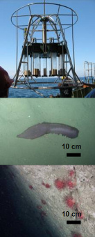
- Underestimation of biodiversity in complex terrains: ecosystem hotspots such as canyons and coral reefs contain true 3D terrain that cannot be surveyed with conventional, ship-deployed sampling gear.
CodeMAP searches for alternative methods to quantify deep-sea biodiversity. The aims are
- To develop a robust, integrated and fully 3D methodology to map complex deep-sea habitats, using a combination of acoustic and visual techniques
- To quantify the heterogeneity of those habitats at a variety of scales, and establish statistical relationships between those scales
- To test the potential of habitat heterogeneity as proxy for epibenthic megafauna biodiversity.
Project approach
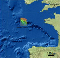
CODEMAP focuses at first on submarine canyons, but the techniques will be transferable to other deep-sea environments, for example, cold-water coral reefs or mid-ocean ridges.
We will start from existing datasets collected during the HERMES and HERMIONE projects, or under the NERC OCEANS2025 and MAREMAP programmes, but new data will be collected during two further expeditions:
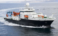
- JC060 (May/June 2011) on board the RRS James Cook. This cruise will be used to develop specific techniques while carrying out habitat mapping for the assessment of trawling impacts and conservation results.
- A second cruise, now scheduled for summer 2015, returning to Whittard Canyon (Celtic margin) to ground-truth the classifications developed in CodeMAP, to monitor potential changes, and to further test sideways mapping techniques.
Facts and figures
- Five year project
- Start 1 April 2011
- 1.4 million Euro
- Two cruises
Work packages
The research will be organised around four themes:
- Top-down analysis: robust mapping of habitats and marine landscapes on the regional to medium scale
- Quantification of habitat heterogeneity and evaluation of its potential as proxy for biodiversity
- Bottom-up analysis: finding quantitative relationships that can bring information from a more detailed to a broader scale
- Habitat heterogeneity in 3D through mapping and visualisation